


All Sunday walks start with a gathering at Fleckney village car park (///loses.always.huts) at 9:30 a.m.
Monks Kirby, Pailton, Willey
by John and Denise Plews
A Ramble with Character
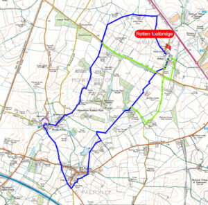
A scenic circular wander beginning and ending at The Denbigh Arms in Monks Kirby, linking the historic villages of Pailton and Willey via farm tracks, quiet bridleways, and open fields. It’s just under 8 miles, gently undulating, and mercifully light on stiles — ideal for stretching the legs without testing the knees.
A Pub with Pedigree
With prior arrangement, park at The Denbigh Arms (///widen.poker.sway). This rustic, stone-built pub opened in 1769, back when George III was still new to the throne and trousers buttoned at the knee. It sits opposite St Edith’s Church and takes its name from the Earls of Denbigh — the Feilding family — who have owned the surrounding Newnham Paddox estate since the 1400s. The pub still oozes old-world charm: open fires, historic photos, and a dog-friendly welcome.
Unusual fact: The Feildings once claimed descent from the Habsburgs — yes, the Holy Roman Emperors — thanks to a genealogical “misunderstanding” that lasted for centuries. It was quietly dropped when historians pointed out the family tree had more imagination than evidence.
The Walk
Monks Kirby to Coventry Road
Head down Miller’s Lane, then on to Bell Lane. Eventually the tarmac gives up and the lane becomes concrete. Where the lane bends sharply left, take the bridleway straight ahead — unless you fancy an unexpected tour of the sewage works.
The bridleway leads to Coventry Road. Cross carefully and rummage in the hedgerow until you locate the footpath. Some of the stiles and footbridges along this stretch are shy, retiring types — not well signposted and seemingly ignored by both walkers and councils. A shame, but part of the adventure.
Yews Farm to Pailton
The footpath heads south past Yews Farm and eventually pops out onto the B4112. Cross over and go through the large wooden gates opposite (or the small metal one if the big gates are feeling antisocial). This section is poorly signposted but easy enough to follow.
Continue down the track until you reach a sort of crossroads. Look left for a gap in the hedge (///blurs.suitable.workouts). Slip through, cross the field, and keep an eye out for the exit gate — the waymarks here favour subtle white discs over helpful yellow posts.
Beyond the gate, three fields open up before you, each one larger than the last. At the far end, look for a jitty beside a house. This leads you onto Lutterworth Road at the eastern edge of Pailton. Cross over and head through the obvious gateway onto a friendly, well-walked footpath.
Unusual fact: Pailton once had a windmill that doubled as a signalling point during the Napoleonic Wars. Villagers claimed you could see all the way to Coventry from the top — though this may have depended on how much ale had been consumed beforehand.
Pailton to Willey
The path meanders through fields and skirts Newnham Paddox Park, where it becomes a bridleway. Just after The Kennels (map recommended), you can either continue straight or turn right onto a footpath. Both options eventually cross Coal Pit Lane and enter the tiny village of Willey.
For clarity: Willey rhymes with silly. Insert your own jokes responsibly.
Willey’s Curiosities
Willey boasts St Leonard’s Church, a Grade II listed gem with 14th‑century roots, and the Sarah Mansfield pub. Originally The Plough, it was renamed in the 1970s after the landlord’s grandmother — a rare honour, and one she probably didn’t expect.
More recently, the pub made headlines in 2020 when new owners (of the famously wonky Crooked House pub) gutted the interior without planning permission. Rugby Borough Council intervened, and the village lost yet another local.
Unusual fact: Willey once had a railway halt used almost exclusively by estate workers and foxhunters. Trains would stop only if someone waved a red flag — a wonderfully low-tech request system.
Willey to Brockhurst Lane
The original route heads northwest out of Willey over a rotten footbridge (passable with care), then into a maize field with no obvious path, followed by an unmarked open field. These obstacles are precisely why recces exist.
The path arcs around and meets Coal Pit Lane. Alternatively, you can simply walk along Coal Pit Lane from Willey and arrive at the same point — the junction with Brockhurst Lane.
Fun Fact: Why We Call It a “Leg”
When sailing against the wind, ships must zig-zag — a manoeuvre called tacking. Each straight stretch is a leg. By the early 20th century, the term had wandered ashore and became a general word for any stage of a journey. So yes, you are now on the next leg of your walk — without needing a mast or a stiff breeze.
Brockhurst Lane to Monks Kirby
Brockhurst Lane offers excellent views — this is the highest point of the walk. It leads to Brockhurst, a tiny hamlet northeast of Monks Kirby, then continues into the village itself. Follow the lane until it meets Main Street, keep going straight (resist the temptation to veer off at Bond End), and soon The Denbigh Arms comes into view.
Unusual fact: Monks Kirby was once home to a medieval priory whose monks brewed ale so strong it was said to “fell a man faster than prayer could raise him”. Sadly, the recipe has been lost to time — or possibly hidden in a very smug monk’s diary.
General information:
The Fleckney Walking Club offers a range of walks for anyone who enjoys fresh air, good company, and the occasional debate about whose turn it is to get lost.
All walks start from Fleckney Village car park (What3Words: ///loses.always.huts).
Weekday Morning Walks
We head out every weekday at 8:30 a.m. for a 3–6 mile leg‑stretcher. These are friendly, local, and an excellent excuse to pretend we’re “morning people”.
Sunday Walks
Every Sunday we meet at 9:30 a.m.
The Sunday programme alternates each time:
- Every week: a short walk (4–6 miles) with a coffee stop
- Every other week: a medium walk (6–8 miles) with a pub stop
And so the cycle continues, like a well‑oiled machine… or at least a machine that’s had a coffee or a pint.
Good boots and weatherproof layers are strongly advised, especially for those who attract rainclouds. Bring refreshments too — a coffee or picnic stop is usually part of the ritual.
If we’re travelling outside Fleckney, car sharers are asked to contribute 20p per mile (one way).
Example: 10 miles = £2, plus whatever emotional support the driver requires.
Thursday Evening Walks (Summer)
In summer, we also run Thursday evening walks of 4–6 miles, starting at 7 p.m. from the village car park.
If the programme creeps into September, we shuffle the start to 6:15 p.m. in a brave attempt to outrun the sunset.
Most Thursday walks this year are local, so no transport or complicated logistics — just turn up and look enthusiastic.
Leading a Walk
If you fancy leading a walk, we have plenty of route ideas here. You bring the charm; the rest of us will bring the heckling.
Cancellations
If a walk is cancelled (usually due to weather, occasionally for common sense reasons), the leader will notify everyone via email and WhatsApp and will also appear at the meeting point to console any optimists who turned up anyway.
Membership
Annual membership remains a bargain at £5, which is less than the price of a pint on most of our pub‑stop routes.
Stay Updated
All the latest walk details, updates, and last‑minute dramas appear on our WhatsApp group:
https://bit.ly/4t1lj5V
You can find The Fleckney Walking Club Group on Facebook. This is a private group but you are welcome to apply to join us.
We encourage you to join the Fleckney Walking Club WhatsApp Group.
Please do so by scanning the QR code, following the link below, or contacting Admin.

https://bit.ly/4t1lj5V